
Airspace
Class G
Class G Airspace
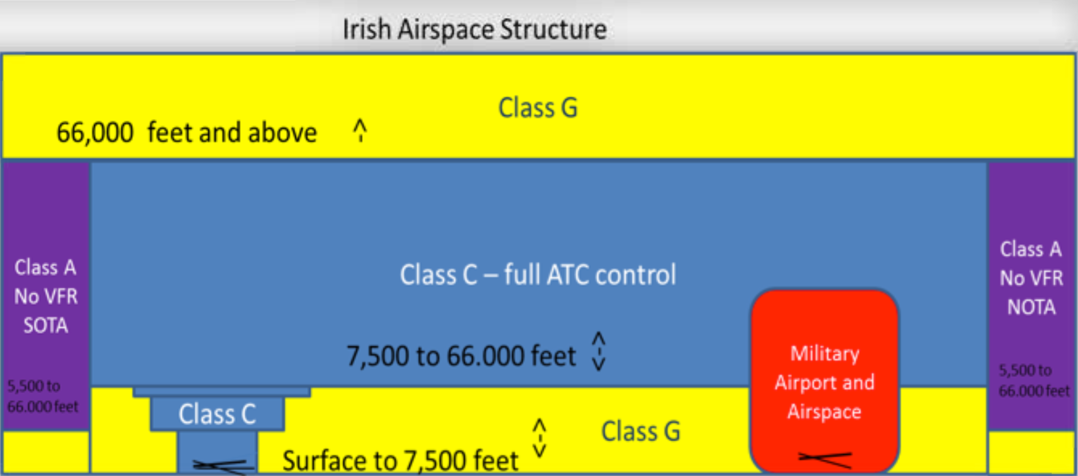
- Class G is uncontrolled airspace - all aircraft must observe normal Visual Flight Rules (VFR)
- Hang Gliders and paragliders may fly in Class G airspace
- Visual Flight Rules
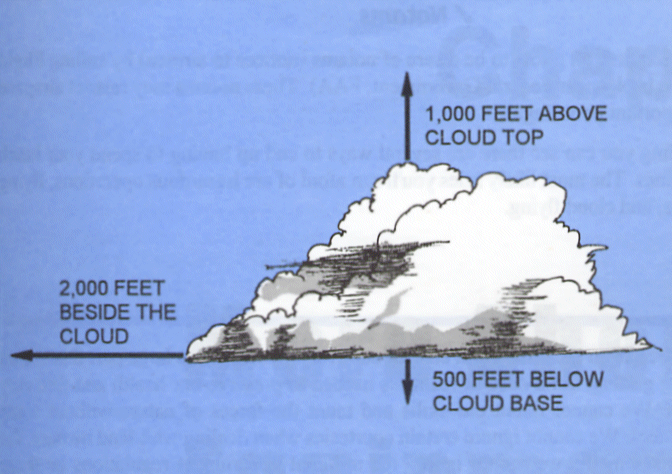
- Vertical Limits: Surface to 7,500 feet AMSL
- Cloud Clearance: 1000 feet above, 500 feet below, 2000 feet lateral
- Visibility: 1 mile.
- Daylight: the sun must be above the horizon
Class C
Class C Airspace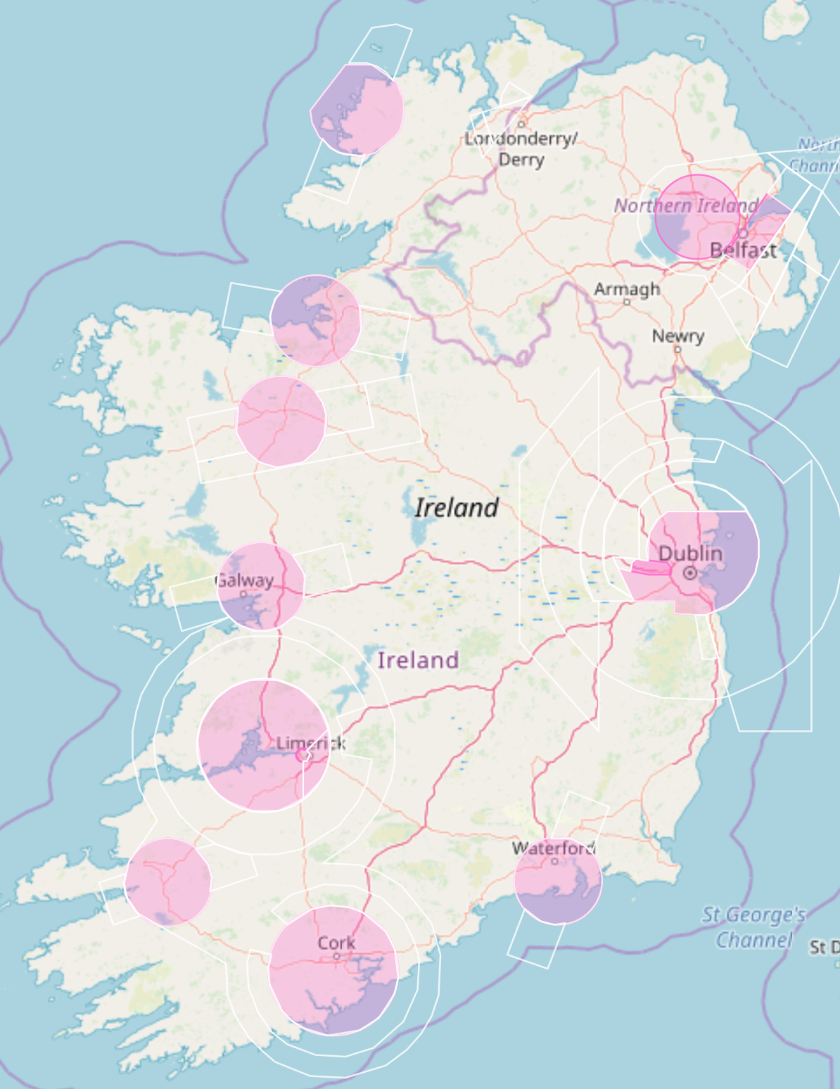
- Surrounding Dublin, Cork and Shannon airports, and...
- Vertical Limits: 7,500 to 66,000 feet AMSL
- Flight Level: FL75 to FL660
- Special Visual Flight Rules apply
- Vertical Limits: Surface to 750 feet AMSL
- Horizontal Limits: 1 nautical mile from launch
- Clearance: Clear of clouds
- Daylight: the sun must be above the horizon
- Pilots must obtain permission from local ATC before launching
- The last pilot out of the air must call local ATC to advise them that flight operations have ceased for the day
- Hang glider and paraglider pilots must obtain specific permission from ATC before flying sites located inside Class C airspace.
- ATC will specify the Special VFR rules that must be observed while flying within Class C airspace.
- The three main airports (Dublin, Shannon and Cork) have extensive Class C controlled areas around them. The smaller airports (Waterford, Knock, Farranfore, Galway, Sligo and Donegal) have a 10 nautical mile radius cylinder of airspace controlled by local ATC. These smaller, regional airports also have additional stubs, generally 10 nautical miles long and wide, along extended runway centrelines, extending from 2500 feet AMSL upwards. These stubs are controlled by Shannon ATC. You can safely fly below these stubs (i.e. below 2500 feet).
Regional Airports
Regional Airports
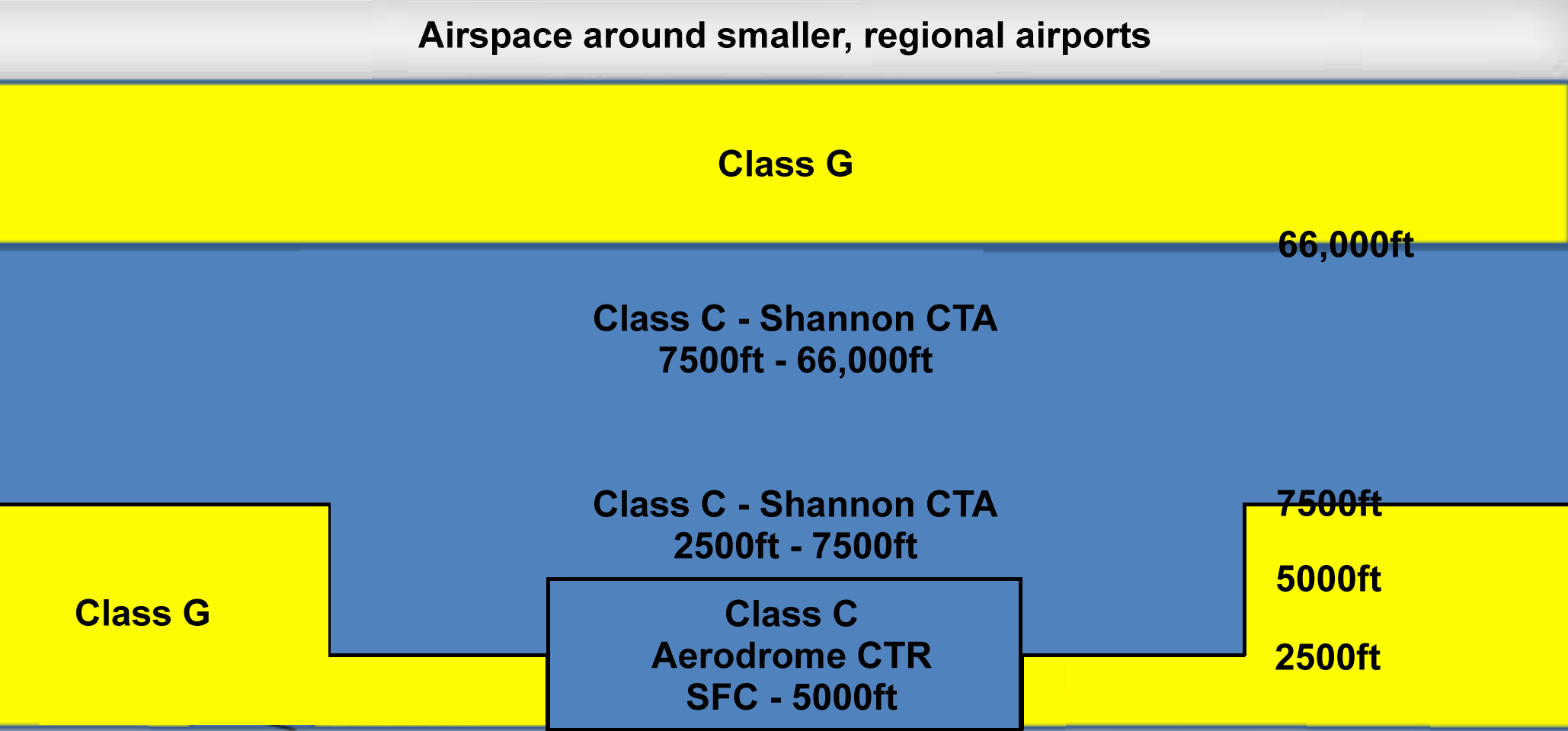
Airspace surrounding the smaller, regional airports consists of a central cylinder with a radius of 10 nautical miles extending from the surface to 5000 feet. This is Class C airspace and is controlled by the aerodrome CTR. Two stubs extend out from the centre line of the runway. The stubs are Class C airspace and are each 10 nautical miles long, 10 nautical miles wide, and extend from 2500 feet up to 7500 feet. Aircraft flying within the stubs are controlled by the Shannon CTA.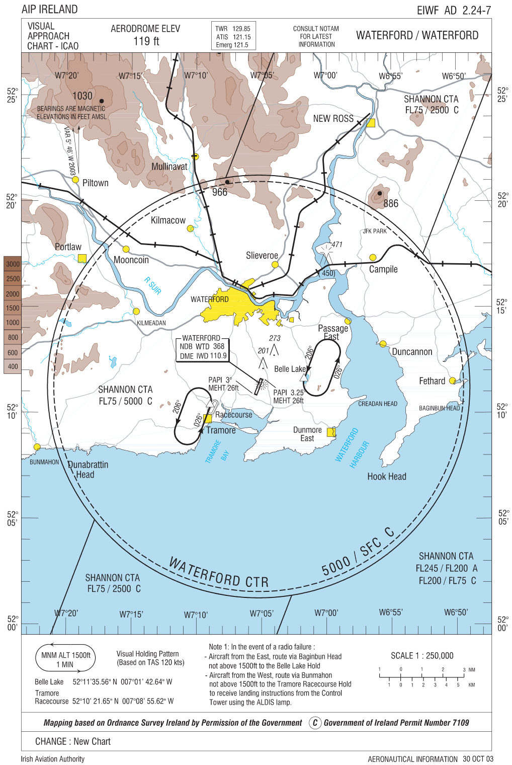
- EIDW - Dublin ATC - 01 8144601 - Call before you fly at Killiney.
- EIME - Casement Military Aerodrome - 01 403 7514 - Call before you fly at Lacken.
- EIWF - Waterford Airport - 051 875265 - Call before you fly the Comeragh Mts.
- EICK - Cork Airport Tower - 021 4329623 - Call before you fly at Kinsale
- EIKY - Kerry (Farranfore) Airport - 066 9764644
- EINN - Shannon Airport - 061 712000
- EICM - Galway Airport - 091 755569
- Note: Galway Airport is no longer open to commercial air traffic and has reverted to Class G airspace.
- EIKN - Knock Airport - 094 936 8100
- EISG - Sligo Airport - 071 916 8461 - Call before you fly at Knocknarae, Truskmore or Benbulbin
- EIDL - Donegal Airport - 074 9548284
Restricted Airspace (EIR)
Restricted Airspace (EIR & TRA)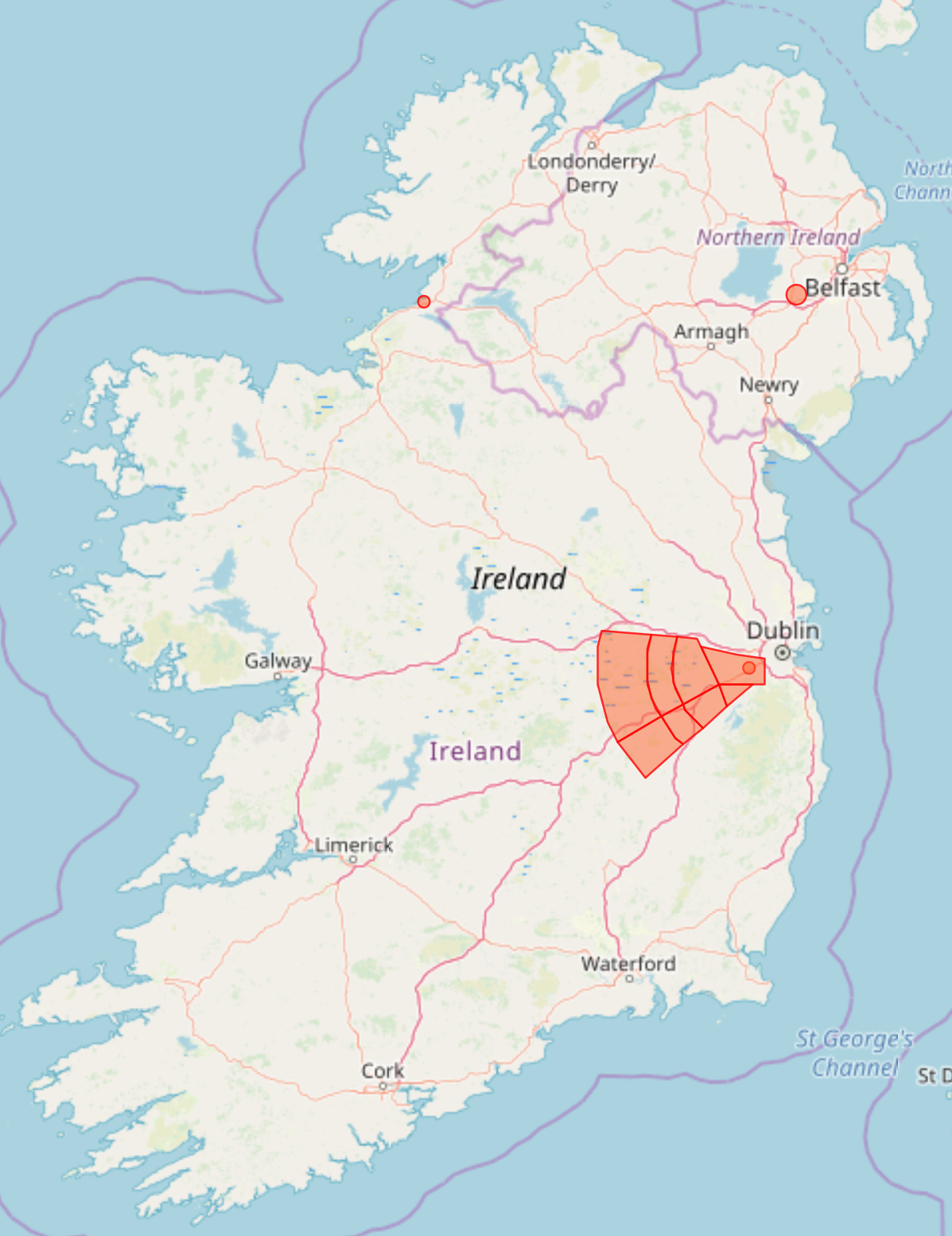
- Military Operating Area
- You may not enter Restricted Airspace (EIR or TRA) when it is NOTAMed as active
- EIR15 - Co. Dublin - Surface to 3000 feet
- EIR16(B) - Co. Dublin - 1000 feet to FL240
- EIR16(C) - Co. Dublin - 1500 feet to 4500 feet
- EIR16(D) - Co. Dublin - 1500 feet to FL240
- EIR16(E) - Co. Dublin - 2500 feet to FL240
- EIR16(F) - Co. Dublin - 3500 feet to FL240
- EIR16(G) - Co. Dublin - 4500 feet to FL240
- EIR16(H) - Co. Dublin - 2500 feet to FL240
Temporary Restricted Airspace (TRA)
The Irish Aviation Authority occasionally issues notices of Temporary Restricted Airspace for specific areas and events. Details of the TRA can be viewed in the NOTAMs. TRAs are issued for such events as public events, festevals, visiting dignatories and military training exercises outside of the regular EIR Restricted Airspace areas.
Danger Areas (EID)
Danger Areas (EID)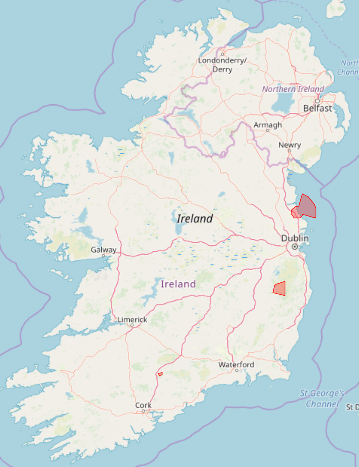
- Military Operating Area / Live Firing Range
- Pilots may not enter danger areas when they are active (see NOTAM Info)
- EID1 - Gormanston Military Range - Co. Dublin - Surface to 40,000 feet
- EID5 - Glen of Imaal Firing Range - Co. Wicklow - Surface to 40,000 feet
- EID6 - Kilworth Firing Range - Co. Cork - Surface to 8000 feet
Prohibited Airspace (EIP)
Prohibited Areas (EIP)
- Areas of national security or national welfare.
- Pilots may not enter these areas under any cirumstances.
- EIP8 - Portlaois Prison - Surface to 5000 feet
- EIP10 - Curragh Military Camp, Co. Kildare - Surface to 5000 feet
VFR & Special VFR
 Visual Flight Rules (VFR)
- Normal Rules of the Air must be observed
- Pilots must maintain visual reference with the ground at all times.
- Visibility must be at least 1 mile.
- Flights may only take place during the daylight hours - the sun must be above the horizon
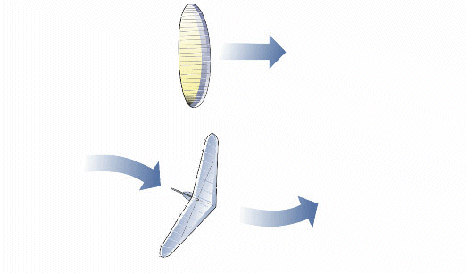
- Pilots must maintain minimum distances from cloud as shown in the graphic to comply with Visual Flight Rules (VFR).
- It is dangerous and illegal to fly inside cloud, as is getting to cloud base.
Special VFR
Hang glider and paraglider pilots flying inside Class C airspace with the specific permission of the local Air Traffic Control (ATC) are by definition flying under Special VFR rules. ATC will state the specific rules and minima that you must observe while flying.
For Killiney Hill, ATC will normally specify that you must remain below 750 feet above mean sea level (AMSL), within 1 mile of your launch point and clear of cloud, and that you must land before sunset. Occasionally ATC may specify different conditions.
Normal Rules of the Air must be observed.
Rules of the Air
Rules of the Air
Rules of the Air
General:
- SEE and AVOID! It is the pilot’s responsibility to take all possible measures to avoid a collision with any other glider.
- A pilot shall not launch (or inflate their canopy) if there are other gliders directly in front of (or crossing) the launch area.
- A glider shall not be flown so close to another glider as to create a danger of collision.
- After taking off, pilots must fly clear of the launching area leaving it clear for other pilots wishing to launch.
- Novice and other low airtime pilots must fly with a broad red ribbon attached to their harness (PG) or kingpost (HG) to identify them to other pilots. All pilots must give these novice pilots a wide berth and not fly close to them or crowd them in the air as they have limited experience and a limited ability to manoeuvre.
Converging Gliders
When two gliders are converging at approximately the same altitude, the glider with the other on its right shall give way (i.e. the glider to the right has right of way.)
Approaching Head On
When approaching approximately head-on with a risk of collision, both gliders shall alter course to the right.
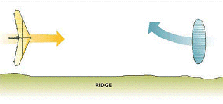
Approaching Head On, on a Ridge
When ridge-soaring, if two gliders are flying towards each other at similar height, the pilot with the ridge to his right has the right of way, and the pilot with the ridge to his left must move out so that the other has room to maintain course without having to turn into or over the ridge.
Overtaking
When overtaking another aircraft you must give it a wide berth and take care not to impede it. A glider may overtake another glider to either the left or right (hang gliders and paragliders are both considered to be gliders). When hill soaring the safest course of action is often to turn back rather than to overtake. If you do need to overtake, make sure that you pass well clear of the other glider.
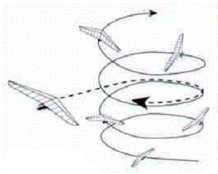
Thermaling
The first glider entering a thermal may decide which direction to turn in. Gliders joining a thermal must give way to gliders already established in it and turn in the same direction regardless of whether they join the thermal above or below other gliders already established in the thermal.
Landing
A glider landing or on final approach has the right of way over all other gliders on the ground.
When two or more gliders are landing, the lowest glider on final approach has the right of way, provided it does not cut in front of or overtakes any other glider on final approach.
After landing, you must clear the landing area as soon as possible.
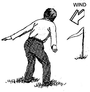
Indicating the Wind Direction from the Ground
When indicating the wind direction to a pilot in the air, face the wind, lean forward, hold your arms out and back like a glider and walk or run into the wind.
The signal for zero wind is to stand up, hold your arms out horizontally from your sides (in a T shape) and turn completely around several times.
Standardised European Rules of the Air
SERA
Standardised European Rules of the Air
[IHPA NOTE: This document was prepared in 2018 by Phil Lardner (IHPA Training & Flight Safety Officer 2000 - 2023) at the request of John Murray (IAA). This document is a work in porogress. This edited version of the SERA rules (i.e. those relevant to IHPA / HG / PG pilots) has yet to be approved by the IAA]
SERA 2018 – VFR and Special VFR Rules
- https://www.easa.europa.eu/document-library/general-publications/easy-access-rules-standardised-european-rules-air-sera
- [VFR Rules: pages 52 - 57]
Phases of flight for HG/PG (not an exhaustive list!)
NOTE: we need to go through each phase of flight and decide which parts of SERA apply
- Launching / Take-off from a hill side (privately owned land or commonage.)
- Top Landing (at or near the Take-off site) on a hill side (privately owned land or commonage.)
- Launching or landing near vertical structures (power lines / transmitter masts etc.)
- Bottom Landing in a privately owned field.
- Ridge / Hill Soaring.
- Flying Cross Country.
- Landing Out after a cross country flight.
- Flying over or near built up areas, vertical structures (antennae) or water.
- Launching / Flying / Landing within a controlled airspace (Killiney / Kinsale) - Special VFR.
QUESTION: What is the altitude limit (ceiling) for Class G airspace in Ireland?
- [Page 11] IAA guide-to-air-traffic-operations.pdf [2025: document is no longer available on IAA website!]
- Surface to 7500ft amsl
- Above 7500ft is Class C airspace.
NOTE: Only Class C and Class G airspaces are physically accessible to HG/PG pilots.
QUESTION: Do we need to issue a permanent NOTAM for HG/PG activities at Killiney / Kinsale? John Murray (IAA) raised this item during the meeting 21Mar2019.
NOTE: HG/PG flights from Killiney and Kinsale are conducted under Special VFR rules, as these sites are inside Class C airspace. Local ATC will dictate the terms of the Special VFR rules. All other flights are in Class G airspace and are covered by normal VFR rules.
ACTION: Find the email from Simon Curthoys / ATC (c2013?) detailing the protocol for contacting ATC and the conditions for flying Killiney / Kinsale (and Sligo.) Do we need a formal Letter of Agreement?
ACTION: Provide a list of all our flying sites to John Murray... and the shortened list of the most popular flying sites for the AIP. This is (I think) so that the IAA can grant permission for us to operate from agreed sites and be covered by the SERA rules... possibly!
NOTE: In the following SERA.5000 headings:
- GM1 stands for Guidance Material
- AMC1 stands for Acceptable Means of Communication.
NOTE: The term 'competent authority' means the Irish Aviation Authority (IAA)
NOTE: HG/PG flights from Killiney or Kinsale, which are inside Class C airspace, are conducted under Special VFR rules as agreed with the local ATC Service Provider.
NOTE: The text below is copied directly from the 2018 SERA.5000 document on the EASA website (link at the top of this page)
- Text in red appears to be not relevant to HG/PG pilots and could/should be removed if we put this document up on the IHPA website – our pilots only need to see what is directly relevant to them.
- Text in black appears to be directly relevant to HG/PG pilots... except where noted in blue, where I'm not 100% sure if it applies to us!
SERA.5001 VMC visibility and distance from cloud minima
|
Table S5-1 (*) |
|||
|
Altitude Band |
Airspace Class |
Flight Visibility |
Distance from Cloud |
|
At and above 3050m (10,000ft) AMSL [IHPA NOTE] NOT relevant to HG/PG. This altitude band is out of reach to HG/PG. The vertical limits for Class G airspace in Ireland are Surface to 7500ft AMSL |
A (**) B C D E F G |
8km |
1500m horizontally 300m (1000ft) vertically |
|
Below 3050m (10,000ft) AMSL and above 900m (3000ft) AMSL, or above 300m (1000ft) above terrain, whichever is the higher [IHPA NOTE] Relevant to HG/PG for flights between 3000ft and 7500ft OR 1000ft above terrain, whichever is higher Not relevant to Special VFR flights at Killiney / Kinsale which are limited to 750ft AMSL |
A (**) B C D E F G |
5km |
1500m horizontally 300m (1000ft) vertically |
|
At and below 900m (3000ft) AMSL, or 300m (1000ft) above terrain, whichever is the higher [IHPA NOTE] Relevant to HG/PG for flights from Surface to 3000ft AMSL Not relevant to Special VFR flights at Killiney / Kinsale which are limited to 750ft AMSL |
A (**) B C D E
|
5km
|
1500m horizontally 300m (1000ft) vertically
|
|
F G
|
5km (***) |
Clear of cloud and with the surface in sight |
|
(*) [IHPA Note - Not relevant to HG/PG] When the height of the transition altitude is lower than 3050m (10,000ft) AMSL, FL100 shall be used in lieu of 10,000ft.
(**) [IHPA Note - Not relevant to HG/PG] The VMC minima in Class A airspace are included for guidance to pilots and do not imply acceptance of VFR flights in Class A airspace.
(***)When so prescribed by the competent authority:
(a) flight visibilities reduced to not less than 1500m may be permitted for flights operating:
(1) at speeds of 140kts IAS or less to give adequate opportunity to observe other traffic or any obstacles in time to avoid collision; or
(2) in circumstances in which the probability of encounters with other traffic would normally below, e.g. In areas of low volume traffic and for aerial work at low levels;
(b) [IHPA Note - Not relevant to HG/PG] helicopters may be permitted to operate in less than 1500m but not less than 800m flight visibility, if manoeuvred at a speed that will give adequate opportunity to observe other traffic or any obstacles in time to avoid collision.
SERA.5005 Visual Flight Rules
(a) Except when operating as a special VFR flight, VFR flights shall be conducted so that the aircraft is flown in conditions of visibility and distance from clouds equal to or greater than those specified in Table S5-1.
(b) Except when a special VFR clearance is obtained from an air traffic control unit, VFR flights shall not take off or land at an aerodrome within a control zone, or enter the aerodrome traffic zone or aerodrome traffic circuit when the reported meteorological conditions at that aerodrome are below the following minima:
(1) the ceiling is less than 450m (1500ft); or
(2) the ground visibility is less than 5 km.
(c) [IHPA Note - Not relevant to HG/PG] When so prescribed by the competent authority, VFR flights at night may be permitted under the following conditions:
(1) if leaving the vicinity of an aerodrome, a flight plan shall be submitted in accordance with SERA.4001(b)(6);
(2) flights shall establish and maintain two-way radio communication on the appropriate ATS communication channel, when available;
(3) the VMC visibility and distance from cloud minima as specified in Table S5-1 shall apply except that:
(i) the ceiling shall not be less than 450 m (1500 ft);
(ii) the reduced flight visibility provisions specified in Table S5-1(a) and (b) shall not apply;
(iii) in airspace classes B, C, D, E, F and G, at and below 900m (3000ft) AMSL or 300m (1000ft) above terrain, whichever is the higher, the pilot shall maintain continuous sight of the surface; and
(5) except when necessary for take-off or landing, or except when specifically authorised by the competent authority, a VFR flight at night shall be flown at a level which is not below the minimum flight altitude established by the State whose territory is overflown, or, where no such minimum flight altitude has been established:
(i) over high terrain or in mountainous areas, at a level which is at least 600m (2000ft) above the highest obstacle located within 8km of the estimated position of the aircraft;
(ii) elsewhere than as specified in i), at a level which is at least 300m (1000ft) above the highest obstacle located within 8km of the estimated position of the aircraft.
(d) [IHPA Note - Not relevant to HG/PG] VFR flights shall not be operated:
(1) at transonic and supersonic speeds unless authorised by the competent authority;
(2) above FL195. Exceptions to this requirement are the following:
(i) an airspace reservation has been established, where practical, by the Member States, in which VFR flights may be allowed; or
(ii) airspace up to and including FL285, when VFR traffic in that airspace has been authorised by the responsible ATS unit in accordance with the authorisation procedures established by the Member States and published in the relevant aeronautical information publication.
(e) [IHPA Note - Not relevant to HG/PG] Authorisation for VFR flights to operate above FL285 shall not be granted where a vertical separation minimum of 300m (1000ft) is applied above FL290.
(f) Except when necessary for take-off or landing, or except by permission from the competent authority, a VFR flight shall not be flown:
(1) over the congested areas of cities, towns or settlements or over an open-air assembly of persons at a height less than 300m (1000ft) above the highest obstacle within a radius of 600m from the aircraft;
(2) elsewhere than as specified in (1), at a height less than 150m (500ft) above the ground or water, or 150m (500ft) above the highest obstacle within a radius of 150m (500ft) from the aircraft.
[IHPA NOTE: Following a meeting (21/3/2019) with the Irish Aviation Authority to discuss this point, the IAA feel that there is no need for an exemption for our sport. The IAA considers unpowered gliding aircraft descending below 150m to be in a landing phase of flight ("you'd be mad not to have a landing field picked out if you're that low") and therefore covered by paragraph (f) "except when necessary for take-off or landing..." If a glider subsequently hooks a thermal (below 150m) and starts climbing then they consider us to be in a take-off phase of flight.]
(g) [IHPA Note - Not relevant to HG/PG] Except where otherwise indicated in air traffic control clearances or specified by the competent authority, VFR flights in level cruising flight when operated above 900m (3000ft) from the ground or water, or a higher datum as specified by the competent authority, shall be conducted at a cruising level appropriate to the track as specified in the table of cruising levels in Appendix 3.
(h) VFR flights shall comply with the provisions of Section 8:
[IHPA Note – I 'think' this is relevant to us... but I'm not sure! Section 8 deals with Communications and Separation Minima.]
(1) when operated within Classes B, C and D airspace;
(2) [IHPA Note - Not relevant to HG/PG] when forming part of aerodrome traffic at controlled aerodromes; or
(3) when operated as special VFR flights.
(i) [IHPA Note - Not relevant to HG/PG] A VFR flight operating within or into areas or along routes designated by the competent authority, in accordance with SERA.4001(b)(3) or (4), shall maintain continuous air-ground voice communication watch on the appropriate communication channel of, and report its position as necessary to, the air traffic services unit providing flight information service.
(j) [IHPA Note - Not relevant to HG/PG] An aircraft operated in accordance with the visual flight rules which wishes to change to compliance with the instrument flight rules shall:
(1) if a flight plan was submitted, communicate the necessary changes to be effected to its current flight plan; or
(2)as required by SERA.4001(b), submit a flight plan to the appropriate air traffic services unit as soon as practicable and obtain a clearance prior to proceeding IFR when in controlled airspace.
[IHPA Note - Not relevant to HG/PG]
GM1 SERA.5005(c)(3)(iii)Visual flight rules ED Decision 2016/023/R
NIGHT VFR ON TOP
AMC1 SERA.5005(f) Visual flight rules ED Decision 2013/013/R
VFR MINIMUM HEIGHTS - PERMISSION FROM THE COMPETENT AUTHORITY
The competent authority should specify the conditions under which the permission is or may be granted, including the minimum heights above the terrain, water or the highest obstacle within a radius of 150m (500ft) from an aircraft practising forced landings, a balloon or an aircraft executing ridge or hill soaring.
[IHPA Note – The IAA have stated that they will grant permission to hill soar any site at any altitude on condition that we provide them with a list of all our flying sites and as long as we have permission from the landowner (or any of the landowners in the case of commonly owned land.) The IAA are happy to add new flying sites to the list of agreed flying sites on request.]
GM1 SERA.5005(f) Visual flight rules ED Decision 2013/013/R
VFR MINIMUM HEIGHTS - PERMISSION FROM THE COMPETENT AUTHORITY
Subject to an appropriate safety assessment, permission from the competent authority may also be granted for cases like: [IHPA NOTE: I'm not sure how this is relevant to HG/PG... but I'm leaving it in for now!]
(a) aircraft operating in accordance with the procedure promulgated for the notified route being flown;
(b) [IHPA Note - Not relevant to HG/PG] helicopters operating at a height that will permit, in the event of an emergency arising, a landing to be made without undue hazard to persons or property on the surface;
(c) [IHPA Note - Not relevant to HG/PG] aircraft picking up or dropping tow ropes, banners or similar articles at an aerodrome;
(d) any other flights not specified above, where specific exemption is required to accomplish a specific task.
SERA.5010 Special VFR in control zones Regulation (EU) 2016/1185
Special VFR flights may be authorised to operate within a control zone, subject to an ATC clearance. [IHPA Note - Not relevant to HG/PG] Except when permitted by the competent authority for helicopters in special cases such as, but not limited to, police, medical, search and rescue operations and fire-fighting flights, the following additional conditions shall be applied:
(a) such special VFR flights may be conducted during day only, unless otherwise permitted by the competent authority;
(b) by the pilot:
(1) clear of cloud and with the surface in sight;
(2) the flight visibility is not less than 1500m [IHPA Note - Not relevant to HG/PG] or, for helicopters, not less than 800m;
(3) fly at a speed of 140kts IAS or less to give adequate opportunity to observe other traffic and any obstacles in time to avoid a collision; and
(c) an air traffic control unit shall not issue a special VFR clearance to aircraft to take off or land at an aerodrome within a control zone, or enter the aerodrome traffic zone or aerodrome traffic circuit when the reported meteorological conditions at that aerodrome are below the following minima:
(1) the ground visibility is less than 1500m [IHPA Note - Not relevant to HG/PG] or, for helicopters, less than 800m;
(2) the ceiling is less than 180m (600ft).
[IHPA Note - Not relevant to HG/PG]
GM1 SERA.5010 Special VFR in control zones ED Decision 2016/023/R
The list of type of operations subject to permit by the competent authority to deviate from the requirements for special visual flight rules (VFR) flights is not exhaustive. The competent authority may grant a permit for other kind of helicopter operations such as power line inspections, helicopter hoist operations, etc.
[IHPA Note - Not relevant to HG/PG]
AMC1 SERA.5010(a)(3) Special VFR in control zones ED Decision 2013/013/R
SPEED LIMIT TO BE APPLIED BY HELICOPTER PILOTS
The 140kt speed should not be used by helicopters operating at a visibility below 1500m. In such case, a lower speed appropriate to the actual conditions should be applied by the pilot.
[IHPA Note - Not relevant to HG/PG]
GM1 SERA.5010(a)(3) Special VFR in control zones ED Decision 2013/013/R
SPEED LIMIT TO BE APPLIED BY HELICOPTER PILOTS
The 140kt speed is to be considered as an absolute maximum acceptable speed in order to maintain an acceptable level of safety when the visibility is 1500m or more. Lower speeds should be applied according to elements such as local conditions, number and experience of pilots on board, using the guidance of the table below:Visibility (m)Advisory speed (kt)8005015001002000120
GM1 SERA.5010(b)(2) Special VFR in control zones ED Decision 2016/023/R
When assessing the prevailing flight visibility, the pilots should use their best judgement. The assessment should be based, for example, on the pilot’s overall flight experience, knowledge of local conditions and procedures, visible landmarks, etc. Furthermore, the pilot should possess the latest weather observations and forecasts.
[IHPA Note - Not relevant to HG/PG]
AMC1 SERA.5010(b)(3) Special VFR in control zones ED Decision 2016/023/R
SPEED LIMIT TO BE APPLIED BY HELICOPTER PILOTS
The 140kt-speed should not be used by helicopters operating at a visibility below 1500m. In such case, a lower speed appropriate to the actual conditions should be applied by the pilot.
GM1 SERA.5010(c) Special VFR in control zones ED Decision 2016/023/R
When the reported ground visibility at the aerodrome is less than 1500m, ATC may issue a special VFR clearance for a flight crossing the control zone and not intending to take off or land at an aerodrome within a control zone, or enter the aerodrome traffic zone or aerodrome traffic circuit when the flight visibility reported by the pilot is not less than 1500m, [IHPA Note - Not relevant to HG/PG] or, for helicopters, not less than 800m.
Aeronautical Charts
Aeronautical Charts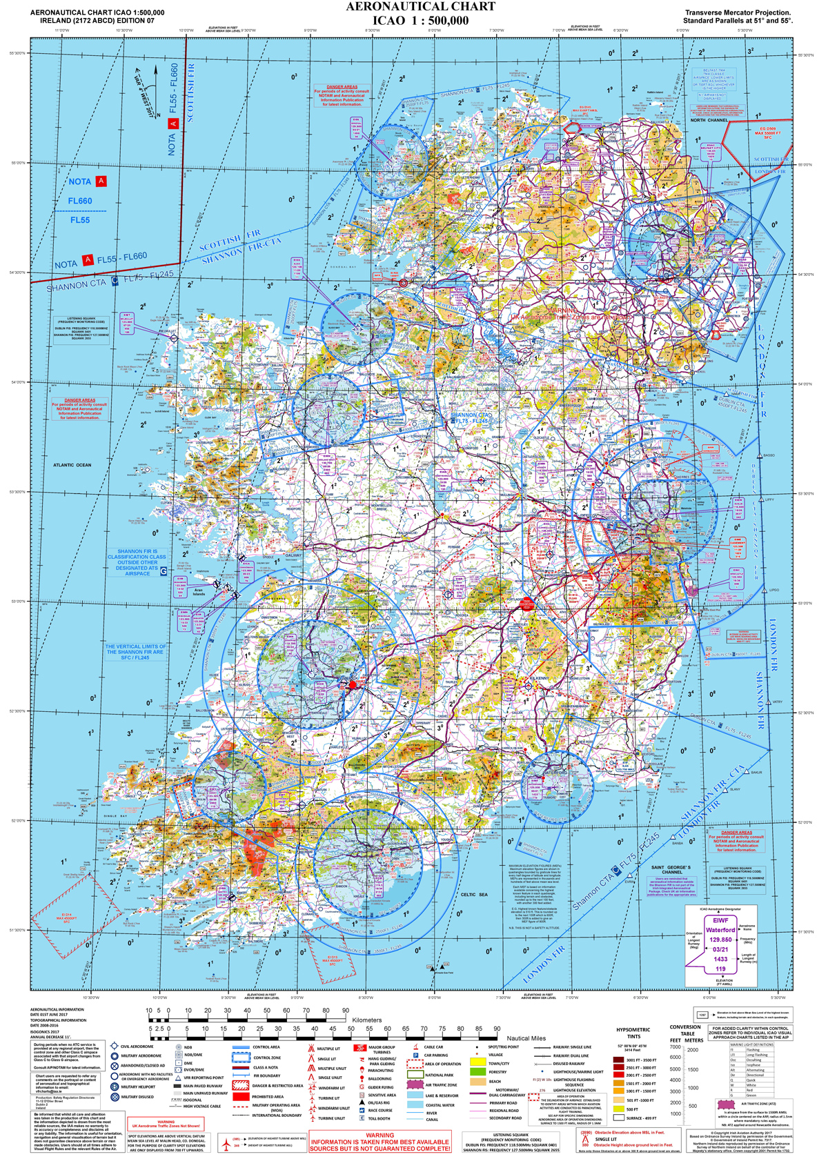
All pilots are strongly advised to own an up to date Sectional Chart showing the extent and limits of controlled airspace in Ireland. VFR sectional charts are available from the Ordenence Survey of Ireland shop in both 1:250,000 and 1:500,000 scale.
The 1:250,000 charts are more detailed and come in four charts covering all of Ireland.
The 1:500,000 chart covers all of Ireland on a single chart, and is sufficiently detailed for IHPA pilots to safely plan cross country flights.
Flight Level (FL) on aeronautical charts is an expression of altitude in hundreds of feet. Thus FL25 is 2,500 feet, FL75 is 7,500 feet and FL350 is 35,000 feet.
Controlled airspace around the larger airports of Dublin,Shannon and Cork are defined by at least three concentric circles: the outer, largest circle is usually defined as Class C FL245/3500FT, which tells you that within this circle controlled airspace extends from 24,500 feet down to 3,500 feet AMSL.
The next, smaller circle is usually defined as Class C FL245/2500FT extends from the same upper altitude of 24,500 feet and comes down closer to the ground to 2,500 feet.
The centre circle is usually defined as Class C FL245/SFC and extends all the way to the surface (SFC.)
NOTAMS
Flying Sites Affected by Airspace
Flying Sites Affected by Airspace
Introduction
The following flying sites are located either inside, underneath or near controlled air space and require either specific permission or knowledge before they may be flown. Please be aware that by flying these sites without permission or by violating the restrictions laid down by Air Traffic Control you are endangering not only your own life but also the lives of others. You also run the risk of having a good flying site closed permenantly and earning the emnity of every other pilot in the country. The rules and restrictions are there for your safety and the safety of others - obey them.
All hang gliding and paragliding flights must be conducted in accordance with Normal Visual Flight Rules unless express permission is granted by Air Traffic Control, in which case the flight is governed by Special Visual Flight Rules.
- Normal VFR - This is a daylight flight with three miles visibility and 1000' clearance from clouds (verticle and horozontal clearance.)
- Special VFR - This is a clearance, from ATC, permitting a VFR flight to operate in controlled airspace with minimums of 1 mile visibility, and "clear of clouds."
- VFR ends at sundown, when the sun touches the horizon. This is a different time each day, which ATC will advise you of.
Killiney
Killiney (Co. Dublin) - This site is inside Class C airspace for Dublin airport and may only be flown with the expressed permission from Dublin Air Traffic Control. Permission is always subject to restrictions - you must not fly above 700 feet above sea level and you must remain within one mile of the obilisk on top of the hill. Note, also, that Killiney is a hazerdous site and has a 50-hour restriction on it. Pilots MUST have a minimum of 50 hours air time experience before attempting to fly there. Following a safety review in 2007 a new protocol has been agreed with Dublin ATC. Permission to fly at Killiney is based on the following ATC stipulated conditions:
- Pilots are required to be current members of the IHPA.
- Pilots are required to hold a minimum pilot rating of Para Pro 3 (or Safe Pro 3) or above.
- Pilots are required to have logged in excess of 50 hours of air time experience.
- Pilots are required to hold a suitable and valid insurance policy.
- Pilots are required to call Dublin ATC for permission to fly (and to notify ATC after flying activities have ceased for the day.)
Pilots wishing to fly at Killiney MUST contact Dublin ATC on 01 8144601 and ask for the Data Assistant. A typical call will go as follows:
Pilot: "Hello, may I speak to the Data Assistant please?"
Dublin ATC: "This is the Data Assistant speaking, how can I help you?"
Pilot: "My name is Joe Bloggs. I am a Paraglider / Hang Glider pilot seeking permission to fly at Killiney Hill."
Dublin ATC: "Ok, when do you wish to commence flying operations at Killiney?"
Pilot: "From now (give the current time) until the end of VFR (Visual Flight Rules) and I would be grateful if you would advise all powered aircraft to avoid this area please."
Dublin ATC: "One moment please while I check with the Duty Controller."
At this point your call may be passed on to the Duty Controller and you should repeat your request again to him.
Dublin ATC: "Ok, you are cleared to fly at Killiney from now until the end of VFR which is at 18:30 (or whatever time VFR ends at.) Your flight operations are restricted to under 700 feet AMSL (Above Mean Sea Level), clear of cloud and within one mile radius of Killiney Hill. Please call back when flight operations have ceased for the day."
Pilot: "Ok, just to confirm: I am cleared to fly at Killiney Hill from now (give the time) until the end of VFR at 18:30 (or whatever time you were told.) Flight operations are to be restricted to under 700 feet AMSL, clear of clouds and to within one mile radius of Killiney Hill. Correct?"
Dublin ATC: "That's correct. Thanks for calling." Click, burrrr....
Remember, your call is being recorded so keep your conversation polite, courteous and professional - stick to the script!
If helicopters or other small aircraft fly close in front of Killiney Hill while you are flying, please do not call Dublin ATC to complain. Note down the time and date of the incident and the type of aircraft infringing your agreed airspace and call or email the IHPA Training & Flight Safety Officer who will take appropriate action. Remember, you are receiving PERMISSION to fly at Killiney Hill, not a cast iron guarantee that you have the air all to yourself!
At the end of a day's flying, normal practice is that the last pilot out of the air MUST call Dublin ATC back to advise them that flight operations have ceased for the day. Again, a typical call will go as follows:
Pilot: "Hello, may I speak to the Data Assistant please?"
Dublin ATC: "This is the Data Assistant speaking, how can I help you?"
Pilot: "My name is Joe Bloggs. I am calling to advise you that Paragliding / Hang Gliding flight operations at Killiney Hill have ceased for the day."
Dublin ATC: "Paragliding / Hang Gliding operations have ceased for the day at Killiney Hill. Ok, thanks for your call." Click, burrr...
Gormanston
Gormanston Dunes (Co. Dublin) - The coastal sand dunes adjacent to the Gormanston Military Camp are inside the EID1 Danger Area. The Irish Defense Forces regularly conduct live fire artillery, rifle and weapons exercises from this location (and out to sea) throughout the year. The Department of Defense has asked us not to fly either paragliders or hang gliders along this stretch of the coast as they consider it inherently dangerous. The irregular periods when the EID1 airspace restriction is active are published by NOTAM (Notices to Airmen.) Please do not fly or infringe on this Danger Area when it is active. Pilots can review the active NOTAMs for Ireland here: NOTAM Info
Bray Head
Bray Head (Co. Wicklow) - Bray Head lies below the Dublin Control Traffic Area, which extends from 2500 feet upwards. You are unlikely to reach 2500 feet at Bray so there is little danger of infringing on that... but it is pssible, so be aware!
Lough Bray
Lough Bray (Co. Wicklow) - Lough Bray lies just south of the Dublin Control Zone. Do not go over the back of Lough Bray towards Tallaght because you will first enter Dublin Control Zone, and then cross into Baldonnel Restricted airspace. Heading west towards the transmitter on Kippure is fine. Lough Bray is part of the Wicklow Mountains National Park. The WMNP Authority requires all sporting activities taking place within the park to be approved and subject to conditions covered in their Permit. Click >here< to view the WMNP Permit.
Paragliding and hang gliding are NOT PERMITTED at Lough Bray or Maulin between the 1st March and 31st July. This is to facilitate the breeding cycle of the Peregrine Falcons that nest in the area.
Lacken
Lacken (Co. Wicklow) - This site is in airspace controlled by Casement Military Aerodrome at Baldonnel. Check airspace class and restrictions. Call Casement ATC on 01 403 7514 if you plan to fly there mid-week and alert them to your activities. There have been a number of instances where low-flying helicopters have come close to PGs/HGs in the air.
Arra, Keeper & Silvermines
Arra, Keeper Hill and Silvermines (Co. Tiperrary) - Keeper Hill and most of the Silvermines are below the Shannon Control Area. Pilots should call Shannon ATC on 061 770700 and ask to speak to the Supervisor. The main directions on Arra are South West to West. It is possible to fly it on a Northwesterly but you need a stiffer breeze. Take off is about 1500 and when you ring ATC, they normally give you 1000ft above the hill. On rare occasions they can give you more height than this but usually only about another 500 ft. Keeper Hill is slightly further away from Shannon than Arra. The Hill is 2200 ft and normally one can get to 3500 AMSL clearance from ATC. Going cross country from Keeper is taking a fairly big risk. There is a lot of air traffic passing over (below cloudbase regularly) and as a result, we haven't flown there that often in recent years. Best directions for flying Keeper is NE right around to SW. Bear in mind the NE take off involves a nerve racking take off over a huge gully. (nearly a cliff launch).
Blackstairs Mts.
Blackstair Mountains (Co. Wexford/Carlow) - Pilots flying cross country off the southern end of the Blackstair Mts. should be aware that there is controlled air space around Waterford City and should plan their flight path accordingly.
Comeragh Mts.
Comeragh Mts. (Co. Waterford) - While this site is not inside any air traffic control zone it is frequently used by the Waterford Search & Rescue helicopter for training exercises. Pilots intending to fly the Comeragh Mts. should call the Search & Rescue base and advise them of your activities before and after you fly. You should specifically explain the danger posed to hang gliders and paragliders from the turbulence caused by the helicopter and request that they do not fly into the area unless there is a genuine emergency. Pilots should also call to advise them when HG/PG activities have ceased for the day. Waterford Search & Rescue: 051 875265.
Kinsale Old Head
Kinsale (Co. Cork) - All flying sites around Kinsale are inside Class C airspace controlled by Cork ATC. Pilots wishing to fly in or through this area must call Cork Tower on (021) 4329623 and request permission to fly. The format for requesting clearance is: "Hello Cork tower, this is a paraglider pilot on the ground at the Old Head of Kinsale. I request clearance for 2 hours paragliding on the cliffs south and west of the Old Head. Maximum altitude 500ft QNH. I will call you when finished." When finished call the tower again and say " the paragliders are on the ground at (say time) at Kinsale." They are very nice people and are now used to us calling them. They want us to let them know what we are doing and always thank us for calling in.
Slieve Mish
Slieve Mish (Co. Kerry) - Part of Slieve Mish is inside the Farranfore CTA (Controlled Traffic Area.) Farranfore airport have made it clear that they will not tolerate any free-flying activity in their airspace unless the pilots are equipped with airband radios and are in direct communication with the Farranfore tower at all times. Airband radios require the operator to have an RT licence. So, for the forseeable future, pilots wishing to fly the length of the Dingle peninsula must not enter Farranfore airspace at any time. Please check your airspace maps before flying in this part of the country. The IHPA will continue to endevour to have this policy changed so that it is treated similarly to other flying sites inside air traffic control zones.
Rossbehy
Rossbehey (Co. Kerry) - This site lies just outside the Farranfore CTA and must be flown with due attention to the extent of Farranfore controlled airspace. Please check your airspace maps before flying this site.
Truskmore & Benbulbin
Truskmore & Benbulbin (Co. Sligo) - Truskmore is on the edge of the Sligo Control Zone. If you fly west or south from Truskmore you are in controlled airspace. Contact Sligo ATC on 071 916 8461 beforehand if you want to fly the hills west of Truskmore, including Ben Bulben. Truskmore and Benbulbin are frequently used by the Sligo Airport based Irish Coast Guard Sikorsky S92 helicopters for SAR training. Pilots MUST contact Sligo ATC prior to flying at any of these locations, including flights in close proximity to Truskmore which are planned to take place outside the Control Zone.
Knocknarae
Knocknarae (Co. Sligo) - This site is right beside (overlooking) Sligo Regional Airport and inside Class C airspace. Permission MUST be obtained from Sligo ATC before flying commences, and XC flights are strictly prohibited. Contact Sligo ATC on 071 916 8461. Local pilots have worked hard to establish a good relationship with the airport, so please don't jeopardise their work by flying without permission!
Northern Ireland
North of Ireland
- Belfast / Aldergrove ATC - 028 9448 4281 - Aldergrove ATC have requested that we use this number when calling to activate designated areas under the LOA.
- Eglinton ATC - 028 7181 1099
Northern Ireland Flying Sites Restrictions
Hello All,
Please read the email below from Mark Piggott/ UHPC concerning the recent change in airspace around Belfast and the Letter Of Agreement (LOA) that has been agreed between the UHPC and Aldergrove ATC to facilitate flying in the affected areas. Please read the email below carefully and understand what it means for you if you are planning on flying in these areas.
The LOA makes specific reference to members of the UHPC and Algergrove ATC so non UHPC members are not covered by it, effectively denying access for non members to the 5 designated areas within Class D airspace described. So if you are planning to fly in these areas and there is the possibility you will infringe Class D airspace you will need a member of the UHPC to activate the LOA. I'm sure all of you who fly north of the border will have contacts within the UHPC and my advice is to get in touch to discuss.
It is essential that you DO NOT INFRINGE CLASS D airspace unless you have prior permission.
This is a legal requirement and applies to us all.
Note: This is a similar arrangement to the LOA between the IHPA and Dublin ATC allowing us to fly at Killiney which is within the Dublin CTR. This has been in place for many years and for the most part works very well. However from time to time, either through lack of knowledge or lack of consideration, a pilot will fly at Killiney without first activating the LOA. This is a serious breach of airlaw and could easily result in the LOA being retracted and the site being closed to us all. Don't be fooled that you won't be seen - Killiney is visible from Dublin control tower and ATC receive constant updates from the GA and commercial airline traffic so it is highly likely they know when we are flying there.
Many thanks, and safe flying,
David May
IHPA Secretary
=======================================================
Email from Mark Piggott of UHPC
=======================================================
Please read this very carefully.
On Thursday 26-May-2016 all Class E airspace in the Belfast TMA will be reclassified to Class D.
Paragliders and hang gliders are permitted to fly in Class E without contacting Air Traffic Control (ATC) but this is not the case for Class D.
Class D is effectively closed to us.
This reclassification affects the following sites:-
|
Site |
Soarable Wind Direction |
Hill Height |
Class D (formerly Class E) |
|
1.1 Knockagh Monument |
S-SE |
865 |
2000 |
|
1.2 Agnew's Hill |
E-SE |
1555 |
2000 |
|
1.3 Shane's Hill |
SE |
1555 |
2000 |
|
1.4 Big Collin |
S-SE |
1158 |
2000 |
|
1.5 Divis & Cavehill |
E-SE |
1698 (mast) |
Class D |
|
1.6 Slieve Croob |
N-E |
1752 |
3500 |
|
1.7Slieve Donard |
All |
2789 |
3500 |
The UHPC, BHPA and UGC all strenuously opposed the airspace change and submitted independent but coordinated objections within the consultation period.
Although unable to prevent the airspace change from going ahead, the CAA did make it a condition that Aldergrove ATC must agree and sign a Letter of Agreement (LOA) with the UHPC before implementation.
After a number of meetings and negotiations the LOA was signed yesterday. It defines five “designated areas” or boxes within Class D airspace that UHPC members can activate for our use.
1. Big Collin/Agnews
2. Knockagh
3. Slieve Croob
4. Slieve Donard
5. Divis/Cave Hill (not yet available to fly as negotiations with National Trust continue)
It is possible to soar all these sites (except Divis) without the need to contact ATC provided Class D airspace is not infringed.
This is particularly an issue at Agnew's where Class D starts only 445 feet above the top of the hill - easily reached in good soaring conditions.
If XC flights or high soaring flights are possible then it is essential to contact ATC to activate the 'designated areas' and obtain clearance to fly.
So if you wish to fly in Class D airspace you MUST:
1. Read the Letter of Agreement (attached) and ensure you fully understand it. It is the law.
2. Ensure you have a GPS or properly set altimeter.
3. Ensure you have a working radio tuned to the club frequency 144.725MHz
4. Follow the "UHPC Procedure" defined in section 6.1 precisely.
This is an extract from the LOA, however before contacting ATC you must read and fully understand the LOA.
The LOA contains the box boundaries and illustrative maps.
6.1 UHPC Procedure
1. All UHPC pilots must be briefed before activating this LOA.
2. A UHPC pilot will contact ATC at Aldergrove at least 15 mins prior to a planned flight to agree a time window and maximum permitted altitude for the required flying area.
3. When a site is activated, the pilot initiating the activation will leave his name and contact number with ATC in case of emergency.
4. On receiving an emergency call from ATC, the pilot will ensure that the call is responded to within 15 mins. If required, this pilot must have a method of ensuring that the area is vacated and shall advise Belfast/Aldergrove ATC when this is complete.
5. Other pilots must confirm the vertical extent and time window before launch by contacting ATC or another informed pilot.
6. All times agreed between ATC and the UHPC will be ‘local’ time.
7. UHPC pilots will ensure that they are flying with a means of determining altitude (amsl) whether by GPS or barometric altimeter set to QNH. Such devices will have a tolerance of +/- 100ft.
8. Pilots will ensure that they remain within the defined lateral notified areas of each designated site where bounded by Class D Airspace.
9. Pilots will ensure that they meet the VFR flight minima as published for Class D Airspace.
10. A UHPC pilot will notify ATC when flying has ceased earlier than the agreed expiry time.
11. These LOAs refer only to segregated flying activity within Class D Airspace. ATC has no control or authority over other IFR/VFR flights which may be operating within Class G Airspace beneath the designated areas.
12. Pilots must be aware that other VFR flights may transit the Designated Areas during the times of activation.
The "method of ensuring the area is vacated" is by FM radio on the club frequency 144.725MHz.
Regards,
Mark Piggott
Air Liaison Officer - UHPC
Letter of Agreement between NATS and UHPC
{aridoc engine="google" width="700" height="600"}images/flight_safety/airspace/Letter of Agreement between the UHPC and NATS - FINAL.docx{/aridoc}