Notes
Aircheck is a handy utility that allows you to quickly check if your XC tracklog (in .igc format) is valid or if you have infringed controlled airspace. To launch Aircheck, click on the
Aircheck tab above and then click on the '
Choose an IGC file...' button at the top left of the screen. Then select the igc you wish to check. You can transfer tracklogs from your flight instrument to your PC using the
GPSDump utility.
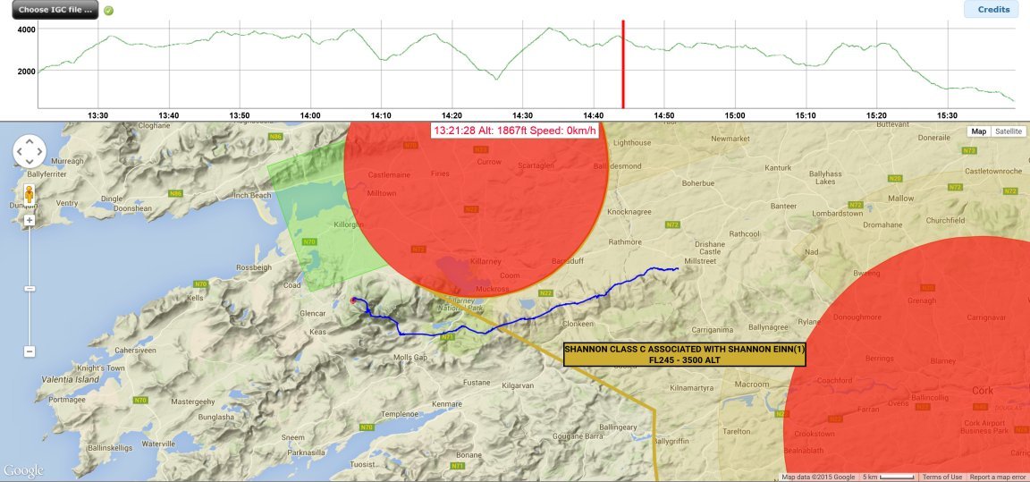
Please note that this is a 'beta' version/implementation of Aircheck. Any questions or problems you may run into should be referred to IHPA Secretary David May who is actively developing this application with the original developer.
Many many thanks to:
- David Wheeler (US) wrote the inital code
- Stein Sorensen (NO) coded GpsDump for Google API conversion
- Matt Rosser (AU) for coding and implementation
- Andreas Rieck (DE) for some code improvements and re-design
- David May (IHPA) for modifying the code to work with Irish airspace and adding several new enhancements to the original code!
Regards
Matt Rosser
XcAustralia Administrator
Provided by XcAustralia using Airspace data valid August 2015 from SoaringWeb.org
Internet Explorer pre version 9 or Safari pre version 6 are not compatible due to DOM standard incompatibility. The application works best with latest Google Chrome, Firefox or Opera. Check compatibility list here.
Disclaimer: This informational service is provided "as is". All data and information contained in any of the data files are provided without guarantee as to their completeness or
correctness. Any conclusions drawn from this data and information are the sole responsibility of the user. This information may not be accurate or current and is not
valid for navigation or flight planning. No warranty of fitness for any purpose is made or implied. Always consult the official publications for current and correct information.
This service is provided free of charge with no warrantees, expressed or implied.
Utilities & Resources
Airspace files for your flight instrument: You can download airspace files for Ireland and other countries here.
GPSDump: Download your tracklogs from your flight instrument with this handy utility.
IGC Flight Replay: Relive your flight by replaying it in 3D with this super utility.
KML_Tool (v1.6.0.1): David May's utility converts OpenAir and SUA format airspace files to the Google Earth format.
[For the IHPA website administrator] - KML_Tool also has a button to convert an OpenAir file to a javascript file for use with the AirCheck application. Instructions to generate the AirCheck javascript version of airspace:
(If you want to include private airstrips then just copy them to the end of the openair file before you load it into the KML_Tool)
For the KML the process is the following:
- Put all the files you want transformed into KML in the same folder. This can be OpenAir file which need to be given the .txt extension and IGC files which need the .igc extension
- The files will be listed in the listbox. Select the files you want processed
- Click the Convert To KML button - this will create a single KML file that will contain the Airspace and/or IGC tracklogs. The Airspace is divided into 4 layers - Below 1000m, Below 2000m, Below 3000m and All IGC tracks will show both the flight track and any declaration if it is present.
- Choose Elevation Exaggeration = 3 for the best effect - it stretches the ground features vertically and makes features more pronounced.
For the AirCheck file the process is similar:
- Click the OpenAir To Aircheck v1 or v2 buttons as appropriate.
- v1 is the format that works with the older version of AirCheck.
- v2 is for the AirCheck version we are using now - the javascript file is slightly different as I am experimenting with being able to load mutiple airspace files at the same time. This will allow for NOTAMs for example
- Save the .js file to the Aircheck /js subfolder
- Modify the aircheck_ie.html file to point to the new javascript airspace file
- Open aircheck_ie.html
- Find the row that references the airspace file - it will look something like <script type="text/javascript" src="/js/airspace_ie_20140710.js"></script>
- Put the name of the new file here
Tracker - by Richard Hunt - This Android app sends periodic text messages to one or two mobile phones (friends, family, retrieve driver or comp organiser) to keep them appraised of your location during a flight and your final landing location. This app can be used as a 'safety net' for lone pilots and is highly recommended. This app can also be used in conjunction with Retrieve Bus, LiveTrack 24 and as a signed IGC flight data logger. It has been extensively tested in competitions and is very simple to use.
XC Pilot Retrieve - by Indy Flyer - This Android app is intended to be used by pilots to help direct the Retrieve Bus driver to their location.
Retrieve Bus - by Indy Flyer - This Android app is intended to be collect text messages from pilots using XC Pilot Retrieve to help organise an efficient retrieve of multiple pilots.
Moovit - Just landed out and didn't think to organise a retrieve? Well done on your unexpected XC! Moovit is an app that will help you get from A to B using public transport wherever you find yourself! It's worth having on your phone... just in case!